Hiking in Sintra: Marked Trails, Walking to Pena and the Best Routes
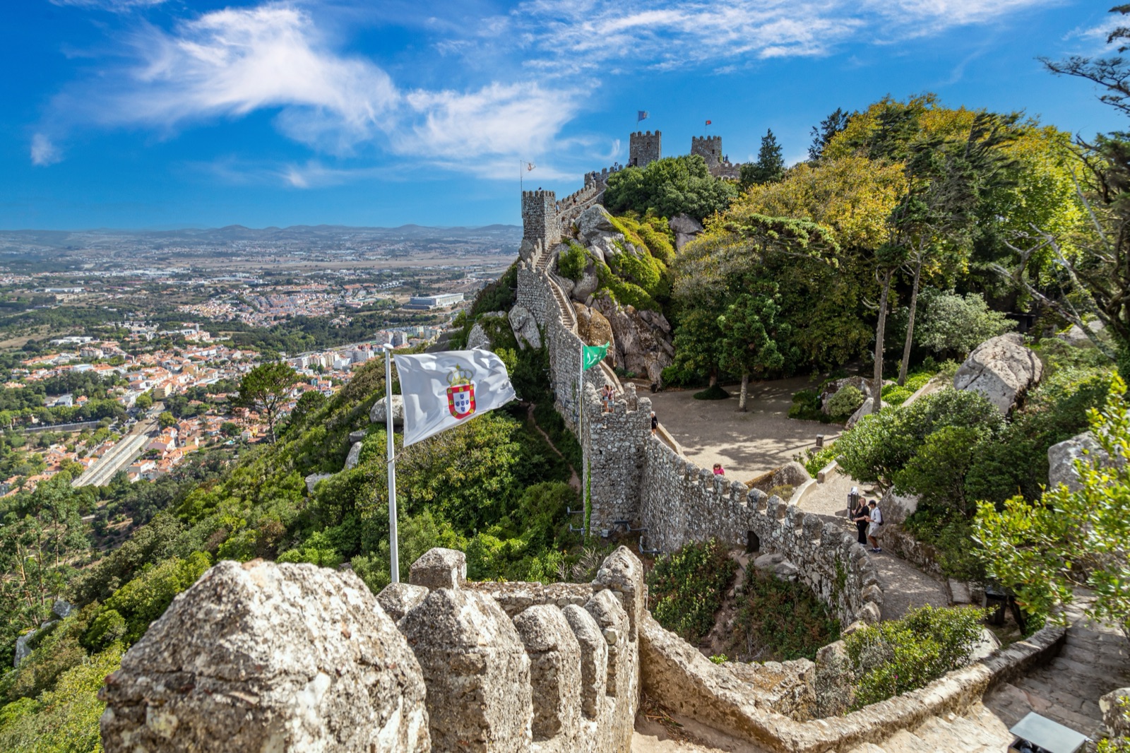
The most popular hike in Sintra is the walk from the historic centre up to the Moorish Castle and Pena Palace, and it is easier than most people expect: the marked Santa Maria trail climbs from the town to the castle in about an hour (1,770 metres), Pena’s main gate is a signposted 30 minutes further, and you can come back down through the free gardens of Villa Sassetti in about 45 minutes. Beyond that, the council and the natural park have waymarked a dozen short routes and a 30 km stretch of the Atlantic Path, from a 1.9 km town loop to 15.5 km of coast and country, all walkable without a guide.
This guide covers the walks from the town to the monuments, the trails inside Pena Park, the longer routes in the hills and along the coast, how to reach the trailheads without a car, the rules of the Sintra-Cascais Natural Park, and what to bring. Distances and descents are those published by Sintra’s municipal tourism service and Parques de Sintra; descent figures are totals, and on a loop you climb the same amount.
Sintra’s trails at a glance
| Trail | Type | Length | Total descent | Start |
|---|---|---|---|---|
| Santa Maria (to the castle) | Linear | 1,770 m (~1 h) | São Pedro de Sintra | |
| Villa Sassetti (to the castle and Pena) | Linear | 1,850 m (~45 min) | Largo Ferreira de Castro | |
| Seteais | Linear | 2,410 m (~1h30) | Palace of Seteais | |
| Short Route 1, Santa Maria | Circular | 1.9 km | 141 m | National Palace |
| Short Route 2/3, Castle and Pena | Circular | 4.5 km | 140 m | National Palace |
| Short Route 4, Seteais | Circular | 3.5 km | 212 m | Historic centre |
| Short Route 5, Quintas | Circular | 2.3 km | 128 m | Historic centre |
| Short Route 6, Rio da Mula | Circular | 11.3 km | 664 m | Rio da Mula dam |
| Short Route 7, Cabo da Roca | Circular | 13.2 km | 497 m | Cabo da Roca |
| Short Route 8, Colares wine | Circular | 15.5 km | 280 m | Adega Regional de Colares |
| Short Route 9, Villages | Circular | 13.5 km | 273 m | São João das Lampas |
| Short Route 10, Peninha | Circular | 5.9 km | 252 m | Peninha car park |
| Short Route 11, Capuchos | Circular | 4.9 km | 343 m | Convent of the Capuchos |
| Short Route 12, Lapiás | — | 8 km | Segueteira Park, Maceira | |
| Short Route 13, North beaches | Circular | 15.5 km | 634 m | São Julião beach |
| GR11-E9 Atlantic Path | Linear | 30 km | 825 m | Cabo da Roca |
The short routes and the Atlantic Path need no guide. They are waymarked on the ground, with a leaflet and downloadable GPS tracks on Visit Sintra’s hiking page, using the standard marks for right way, wrong way and turns.
Walking from the town to the Moorish Castle and Pena
This is the hike nearly everyone does, and the best way to beat the queues for the 434 bus. Parques de Sintra publishes three marked paths up from the town:
- Santa Maria trail: 1,770 metres, about 1 hour. Parques de Sintra’s own day itinerary walks 15 minutes from the National Palace through the old town to the Church of Santa Maria, then about 45 minutes on the path to the Moorish Castle.
- Villa Sassetti trail: 1,850 metres, about 45 minutes, from Largo Ferreira de Castro, 10–15 minutes’ walk from the station. It crosses the gardens of Villa Sassetti, a house in the style of a northern Italian castle designed by Luigi Manini, and joins the castle and the Park of Pena. Access to the gardens and trail is free, 10:00–18:00.
- Seteais trail: 2,410 metres, about 1h30, from the Palace of Seteais, past Quinta da Regaleira.
From the Moorish Castle, a signposted footpath leads to the main entrance of the Park of Pena and up to the palace in about 30 minutes. Parques de Sintra rates its whole walking day “medium, with some climbs”.
Which way round? A common plan, and the one in Parques de Sintra’s own walking itinerary, is to go up by Santa Maria, which reaches the castle first, and come down by Villa Sassetti, which leaves the Park of Pena from the Lakes gate and drops back to the centre. The castle opens 9:30–18:00 (last admission 17:30) and costs €12 for adults; Pena Park opens 9:00–19:00 and the park-only ticket costs €12.
The Pena Trail ticket
Parques de Sintra now sells this walk as a product: “From the Town to the Hills: The Pena Trail”, for €35. It starts with entry to the National Palace of Sintra, then follows the route on foot through Villa Sassetti to the Moorish Castle and into Pena Park through the Lakes Entrance, in about 3 hours. It includes a 400 ml reusable aluminium bottle, collected at the National Palace ticket office with the route information. It covers Pena Park but not the inside of Pena Palace, which needs its own timed ticket. The ticket page warns of uphill sections, changes in level and mixed paving.
Short Route 2/3: the circular version
Visit Sintra’s Short Route 2/3 joins the castle and Pena paths into a 4.5 km loop from the National Palace, with 140 m of descent. On the way you pass the Ferraria viewpoint, the Sabuga fountain (medieval, rebuilt in the late 18th century), the 12th-century Church of Santa Maria, the Casa do Adro, where Hans Christian Andersen lived in 1866, the Convent of the Holy Trinity, the 12th-century chapel of São Pedro de Penaferrim and the grave of the writer Ferreira de Castro (1898–1974). At the top you can visit Pena and the castle.
Short walks in the historic centre
If you want a walk without a big climb, three short loops start in the centre:
- Short Route 1, Santa Maria (1.9 km, 141 m descent). An easy circuit from the National Palace past the Ferraria viewpoint, the Sabuga fountain, the Church of Santa Maria (built by Portugal’s first king, Afonso Henriques, and one of the few medieval buildings left) and Liberdade Park with its exotic plants.
- Short Route 4, Seteais (3.5 km, 212 m descent). Short but with a steep slope, past the clock tower, the Church of São Martinho, Quinta da Regaleira and the 18th-century neoclassical Palace of Seteais, now a hotel. Legend says the name, “seven ais”, comes from an echo.
- Short Route 5, Quintas (2.3 km, 128 m descent). A loop past the old estates on the edge of the town, including Quinta do Relógio and Quinta do Castanheiro, named after its chestnut tree, returning by the Castanhais path.
These combine well with a visit to Regaleira or the National Palace on the same day.
Inside Pena Park
The Park of Pena is a walk in itself, with paths through a planted Romantic forest. Its highlights for walkers:
- The High Cross (Cruz Alta): at 528 metres, the highest point of the Sintra hills, with views north over the farmland, south to the Cascais coast and west to the Atlantic.
- St Catherine’s Heights: a viewpoint over the palace, reached on narrow paths through oak, chestnut and beech wood, with the tiled stone seat known as the Queen’s Throne.
- The Valley of the Lakes: a gentle walk past five lakes linked by small waterfalls, starting at the Little Birds Fountain.
- The Garden of the Countess of Edla: ferns and camellias at the eastern edge of the park.
A park-only ticket (€12 adults, €10 youths and seniors) covers all of it, plus the palace terraces. Parques de Sintra also runs a 90-minute guided tour of the park on Mondays and Tuesdays at 10:30. Our Pena Palace guide explains the tickets and slots.
The mountain routes
West of Pena, the hills are wilder, quieter and much more of a hike.
Short Route 11: Capuchos (4.9 km, 343 m descent)
A good choice for a half-day in the hills: a loop from the Convent of the Capuchos along the top of the range between Cruz Alta and Peninha. It passes viewpoints, a memorial to the soldiers who died fighting the great fire of 1966, the Pedra Amarela, and the Tholos do Monge, a prehistoric collective grave (2500/1500 BC) reused in the Bronze Age (1800/800 BC). Combine it with a visit to the convent itself; see our guide to the Convent of the Capuchos.
Short Route 10: Peninha (5.9 km, 252 m descent)
From the Peninha car park, this loop crosses a windswept landscape shaped by farming and grazing, with views along the coast from Cabo Espichel to the Berlengas islands. The Sanctuary of Peninha, at 488 metres, sits on a heap of rounded boulders, often in fog, with the hermitage of São Saturnino and a small romantic palace built in 1918 for Carvalho Monteiro, the owner of Regaleira. The loop also reaches Adrenunes, where the rocks look like a megalithic dolmen.
Short Route 6: Rio da Mula (11.3 km, 664 m descent)
The toughest of the hill loops: a mountain trail with a sharp gradient from the Rio da Mula dam, on the border with Cascais, climbing through the forest past the Capuchos convent, the soldiers’ memorial and the Pedra Amarela. It runs mostly on the southern side of the hills, more sheltered from Sintra’s characteristic north winds. Visit Sintra warns that in winter the footing is more varied and less stable.
The coast routes
Short Route 7: Cabo da Roca (13.2 km, 497 m descent)
A loop from Cabo da Roca, the westernmost point of continental Europe, along the cliffs past the Pedra de Alvidrar and Buraco do Fojo viewpoints to Praia da Adraga and Praia Grande, then back through the villages of Almoçageme and Ulgueira. It is described as having no steep drops. On the southern cliff of Praia Grande a staircase leads to sixty-six dinosaur footprints dating back 170 million years.
The Atlantic Path (GR11-E9, 30 km)
Sintra’s section of the European long-distance path that follows the Atlantic coast is a linear route of about 30 km, from Ulgueira near Cabo da Roca along the coast past Adraga, Praia Grande, Praia Pequena, Praia das Maçãs, Azenhas do Mar, Aguda and Magoito, then inland to São Miguel de Odrinhas, with its archaeological museum and Roman villa. Despite the length, it is described as accessible and of low physical demand, with no special technique needed. Most people walk a section rather than the whole thing; our article on Cabo da Roca and the Sintra beaches covers the coast stops.
Country and village routes
North of the hills, the landscape changes to the “saloio” countryside: small fields, dry-stone walls, pine woods and villages.
- Short Route 8, Colares wine (15.5 km, 280 m descent): mostly flat, from the Adega Regional de Colares, founded in 1931 and Portugal’s oldest winery cooperative, through pine forest and the old sand-rooted vineyards towards Fontanelas and Gouveia, where the street names are in verse.
- Short Route 9, Villages (13.5 km, 273 m descent): from São João das Lampas through farmland to the restored Roman bridge at Catribana.
- Short Route 12, Lapiás (8 km): from Segueteira Park in Maceira past a limestone pavement to the Mourão river waterfalls at Anços.
- Short Route 13, North beaches (15.5 km, 634 m descent): from São Julião beach along the cliffs past Vigia and Samarra beaches, then inland through Assafora and Catribana, with a stretch of Roman road.
Getting to the trailheads without a car
- The town routes start a 10–15 minute walk from Sintra station.
- Capuchos: bus 1253 from Sintra station leaves you about a 40-minute walk from the convent.
- Peninha: bus 1253 to the Estrada do Cabo da Roca stop, then a 25-minute walk.
- Cabo da Roca: bus 1253 from Sintra station, or line 1624 from Cascais, which runs via the cape to Portela de Sintra.
- Colares and the coast: the Sintra tram runs almost 11 kilometres from Estefânia to Praia das Maçãs in about 45 minutes, with tickets bought on board.
If you drive, use peripheral car parks; private cars may not drive to the Moorish Castle or Pena, and the historic centre is for residents only. Check our guide to getting to Sintra from Lisbon for the train and buses.
Rules on the trails
Most of these walks are inside the Sintra-Cascais Natural Park, which has clear rules:
- Stay on the waymarked trails.
- Keep noise down and watch wildlife from a distance, preferably with binoculars.
- Leave no litter and light no fires of any kind.
- Don’t collect rocks or plants, or camp outside campsites.
- No motor vehicles off the access roads.
Dogs are welcome at the Moorish Castle and in the Park of Monserrate, but not at the other Parques de Sintra monuments, including Pena. The emergency number in Portugal is 112.
Weather, fire risk and closures
The hills make their own weather. Mornings often start with drizzle, fog is common in every month, and the High Cross can be in cloud while Lisbon is sunny. In winter the mountain paths are at their wettest and least stable underfoot.
In summer the risk is fire. Parques de Sintra closes forest sites when access to the hills is restricted: in July 2026 the hill monuments shut until 6 July. Strong winds can also close Pena Park, as they did on 16 December 2025. Check the Parques de Sintra notices before a long walk, and our guide to the best time to visit Sintra for the seasons.
What to bring
- Proper shoes. Paths are steep, rocky and cobbled; the Pena Trail ticket itself recommends footwear suited to the weather.
- Water. There are cafés at the castle and in Pena Park, but little on the mountain and coast routes.
- Layers and a waterproof. It is cooler and windier on the ridges than in the town.
- The GPS track downloaded in advance from Visit Sintra’s hiking page.
- Snacks, eaten outside the monuments: food cannot be taken into Parques de Sintra sites.
A tour instead?
If you want the views without the climb, private classic-car and electric jeep tours cover the hill roads, and small-group tours from Lisbon combine Pena, the castle and the town. Several local companies also run guided walks. Compare options on our tours page.
Frequently asked questions
Can you walk from Sintra to Pena Palace?
Yes. Take the marked Santa Maria trail from the town to the Moorish Castle (1,770 metres, about 1 hour), then the signposted path to the main entrance of the Park of Pena and up to the palace (about 30 minutes). The Villa Sassetti trail (1,850 metres, about 45 minutes) is the usual way back.
How hard is the walk up to the Moorish Castle?
Moderate. It is short but uphill all the way, on stone paths and steps. Parques de Sintra rates its walking day “medium, with some climbs”. Allow about an hour from the town.
What is the best hike in Sintra?
For first-timers, the walk from the town to the Moorish Castle and Pena. For a quieter mountain walk, Short Route 11 from the Convent of the Capuchos (4.9 km). For the coast, Short Route 7 from Cabo da Roca (13.2 km).
Do I need a guide to hike in Sintra?
No. The short routes and the Atlantic Path are waymarked and have leaflets and GPS tracks. Guided walks are available if you prefer company or history along the way.
What is the highest point in Sintra?
The High Cross (Cruz Alta) in Pena Park, at 528 metres, with views to the Atlantic, the Cascais coast and the plains to the north.
Are the trails open all year?
Generally yes, but forest areas can close in high fire risk or extreme weather, and paths are slippery in winter. Check the Parques de Sintra notices before you go.