Nature
Sintra-Cascais Natural Park: Hills, Forests, Cliffs and Trails
The Sintra-Cascais Natural Park, in Portuguese the Parque Natural de Sintra-Cascais, is the protected area that wraps around Sintra. According to the ICNF, Portugal’s nature conservation institute, it covers 14,583 hectares in the municipalities of Sintra and Cascais: the forested granite hills of the Serra de Sintra, the farmland and wine villages to the north, and a wild Atlantic coastline of cliffs, beaches and dunes that includes Cabo da Roca, the westernmost point of mainland Europe. The area has been protected since 1981 and became a natural park in 1994.
The palaces that most visitors come for, Pena, the Moorish Castle, Monserrate and Quinta da Regaleira, all stand inside it, and so does the UNESCO Cultural Landscape of Sintra. But the park is much bigger than its monuments. This article explains how it came to be protected, the rocks and climate that shaped it, its two very different forests, the coast and its curiosities, the plants and birds found there, and how to walk it on the marked trails without a guide.
The park in brief
- Size: 14,583 hectares across the municipalities of Sintra and Cascais, according to the ICNF.
- Protection: a protected landscape area since 1981 and a natural park since 1994; its coast and hills are also part of the European Natura 2000 network.
- World Heritage inside it: UNESCO’s Cultural Landscape of Sintra, inscribed in 1995, covers 946 ha with a buffer zone of 3,641 ha.
- Highest point: the High Cross in Pena Park, at 528 metres.
- Westernmost point: Cabo da Roca, the most westerly point of mainland Europe.
- Best way to see it: on foot, on marked trails that need no guide, or by road along the coast and over the hills.
From protected landscape to natural park
The park’s legal story starts in 1981. A decree-law of 15 October 1981 created the Sintra-Cascais protected landscape area, and a decree of 11 March 1994 turned it into the Sintra-Cascais Natural Park. The ICNF explains why the protection was needed: this is a prime area for tourism and leisure, thanks to its mild climate and the diversity and beauty of its landscape, but it is also a sensitive region under heavy human pressure, right next to Lisbon.
The international recognition followed quickly. In 1995 UNESCO inscribed the Cultural Landscape of Sintra on the World Heritage List, and UNESCO notes that the cultural landscape lies within the natural park and has been protected by national legislation since 1994. The park’s coast and the Serra are also a site of the Natura 2000 network, Europe’s system of protected areas for wildlife and habitats.
The result is several layers of protection on the same ground. The palaces and their gardens are managed as heritage sites, the World Heritage area sits inside a wider buffer zone, and the natural park’s management plan covers the wider landscape around them, from building and farming to recreation.
A mountain made of magma
Seen from a distance, UNESCO says, the Serra de Sintra looks like a small chain of forested granite mountains rising over the hilly farmland. Its geology explains why it stands out. The ICNF describes an igneous massif, formed when magma intruded and rose into Cretaceous and Jurassic sedimentary layers, which now stands out from the sedimentary plateaus around it, in places more than 500 metres above sea level. The oldest rocks visible in the park are sedimentary, laid down 160 million years ago.
You can read this story on the walks. At the Sanctuary of Peninha, on the western end of the Serra at 488 metres, the chapel sits on a chaotic pile of great rounded boulders, sculpted by the erosion of the syenite rock of the hills’ magmatic core. The highest point of all is the High Cross in Pena Park, at 528 metres, with views over Lisbon and Cascais to the south, the Atlantic to the west and the farmland to the north.
The coast keeps traces of the age of the dinosaurs. On the southern cliff of Praia Grande, a staircase leads up to sixty-six dinosaur footprints, pressed into what was once soft ground. Near Cabo Raso, at the southern end of the park, and inland at Granja dos Serrões and Negrais, there are limestone pavements, rock surfaces dissolved into ridges and hollows by rainwater, which the ICNF lists among the park’s most valuable geological features.
Why the hills are so green
The Serra’s shape does more than make a skyline. The ICNF notes that the ridge runs from east to west and acts as a natural barrier to sea winds. Moist Atlantic air is forced up its slopes, cools and condenses, which is why the hills are so often in cloud while Lisbon is in sunshine. That humidity, together with varied soils, supports very diverse vegetation, essentially Mediterranean in character.
The local name for the Serra, Monte da Lua, the Mountain of the Moon, suits its misty moods. Our article on Sintra weather puts figures on the fog and rain and explains what they mean for a visit.
Two forests in one park
The Serra has two very different kinds of woodland, often side by side: what survives of the native forest, and the Romantic plantations of the nineteenth century.
The native woods
The ICNF tells a story of loss. Over centuries the Serra was stripped of its riches until little but scrub remained, and much of its wildlife could no longer survive there. The native oak forest was reduced to remnants in the most inaccessible places, where threatened species such as holly still grow, along with relic plants from before the ice ages such as the fern Asplenium hemionitis.
The best place to sense that older forest is around the Convent of the Capuchos, 8 km from Sintra’s historic centre. Founded in 1560 for Franciscan friars known for living in close harmony with nature, the convent was built into the granite boulders, and Parques de Sintra says the woods around it, kept intact by the friars, are one of the most notable examples of Sintra’s primitive forest.
The Romantic plantations
In the nineteenth century, inspired by Romanticism, the estates of the Serra were transformed into pleasure grounds: palaces surrounded by gardens and woods planted with species from all over the world. The leading figure was Ferdinand II, the king consort who built Pena Palace. UNESCO notes that he also restored the forests of the Serra, planting thousands of trees to add to the oaks and umbrella pines.
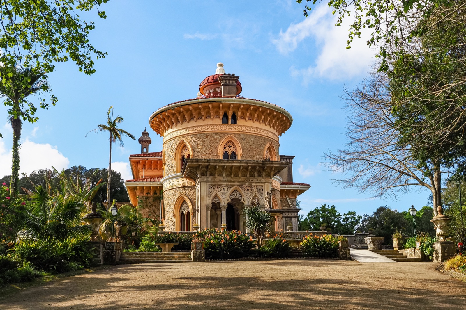
In the 85 hectares of the Park of Pena, Parques de Sintra says, he planted species from every continent, creating what is now the most important arboretum in Portugal; more than 340 species of trees have been identified there. At Monserrate, on the northern slopes, careful study of the land’s microclimates made it possible to plant over 3,000 exotic species. There, tree ferns, palms and Mexican-themed plantings grow beside native species such as tree-sized arbutus, rare holly and cork oaks.
The forest is also vulnerable. A monument on the Capuchos trail remembers the soldiers who died fighting the great fire of 1966, and today the forest areas are cleaned every year to reduce the risk of fire in the hot season.
The wild Atlantic coast
West and north of the Serra, the park meets the ocean. The ICNF describes a long coastline made mostly of live cliffs, high to the north of the Serra and fading out at Cabo Raso. It is also where the park’s rarest plants grow: most of its endemic and threatened species are found on this coastal strip.
A few places stand out:
- Praia Grande is the largest beach on the Sintra coast, known for surfing and bodyboarding, with the dinosaur footprints on its southern cliff.
- Praia da Adraga, to the south, has two curiosities. About fifty metres from the cliff is the Fojo, a natural well roughly 90 metres deep that connects with the sea; the Romans are said to have believed a Triton blew a conch shell at its bottom. On the southern side, the Pedra de Alvidrar drops almost vertically into the sea, and local tradition says young men climbed it as a test of courage.
- Azenhas do Mar is a village strung along a stream that flows into the ocean, named after the water mills, or azenhas, that once stood there. At the foot of its cliffs are a small beach and an ocean pool.
- Guincho, on the Cascais side, is known worldwide for surfing and windsurfing, and for rare geology: coastal limestone pavements running north of Cabo Raso and the Guincho–Oitavos dune system.
The Atlantic here is powerful, and beaches can have strong currents and big surf. Swim only where and when lifeguards are on duty, and treat cliff edges with respect.
Cabo da Roca: where the land ends
At the western tip of the Serra, Cabo da Roca is the most westerly point of mainland Europe. Near the lighthouse, a cross pays homage to the line from Camões’ epic poem, The Lusiads, that describes the place “where the earth ends and the sea begins”. The lighthouse was one of six ordered by the Marquis of Pombal’s charter of 1 February 1758; it began operating in 1772 and is the second oldest on the Portuguese coast. Today Parques de Sintra runs visits to the lighthouse.
Cabo da Roca is reached from Sintra station on Carris Metropolitana bus 1253, or by road over the hills. It is also the starting point for one of the best coastal walks in the park, described below. Our guide to one day in Sintra explains how to combine the cape with the palaces and Cascais in a single day.
Plants found nowhere else
The park’s flora is one of its strongest reasons for protection. The ICNF highlights several plants found only in this part of Portugal, including the thrift Armeria pseudarmeria, the Sintra pink (Dianthus cintranus subsp. cintranus) and the beach forget-me-not Omphalodes kuzinskyanae. Others, such as the catchfly Silene longicilia, survive only in rare, threatened populations on soils formed from the Serra’s granular eruptive rocks.
The rule for visitors is simple: look, photograph, and leave them where they are. Picking plants or collecting rock samples is not allowed anywhere in the park.
Wildlife
The park matters for mammals and birds as well as plants. The ICNF singles out two birds of prey that nest in the park, the peregrine falcon and Bonelli’s eagle. Some of the small streams that run off the Serra are important for the Portuguese nase, a small freshwater fish.
Birdwatching is one of the activities Sintra’s municipality promotes under its ActiveSintra brand, and the trail rules ask walkers to watch wildlife from a distance, preferably with binoculars, and to keep the noise down.
People and produce in the park
The park is not a wilderness. The ICNF notes traces of human presence across it since the Palaeolithic, and describes a traditional rural landscape to the north of the Serra, in the region known as the saloio country, which once supplied Lisbon with much of its food. Four regional fruits are still grown there: the Colares reineta apple, the pêssego-rosa peach, a thick-skinned lemon and the pêra-pérola pear.
The most famous product is Colares wine. Its vines grow close to the sea, sheltered from the strong winds by reed fences, and most of them grow in sand. When phylloxera devastated Portugal’s vineyards in 1865, Colares’s vines were unscathed, largely thanks to the sandy soil the insect could not penetrate, and Colares has been a demarcated wine region since 1908.
One of the nicest ways to cross this farmland is the historic Sintra tram, which runs almost 11 kilometres from Vila Alda, on the edge of Sintra, through vineyards and orchards to Praia das Maçãs, a trip of about 45 minutes.
Walking the park
Sintra’s municipal tourism site describes a network of marked trails in the natural park that can be walked without a guide, using a leaflet, waymarks on the ground and downloadable tracks. A few of the best:
- Peninha (PR10): a circular walk of about 5.9 km from Largo da Peninha, through country moulded by wind and grazing, among great rounded boulders, with views that on clear days reach Cabo Espichel and the Arrábida hills to the south and the Berlengas islands to the north.
- Capuchos (PR11): a circular walk of about 4.9 km along the top of the Serra between the High Cross and Peninha, past the 1966 fire memorial and the Tholos do Monge, a prehistoric collective grave.
- Cabo da Roca (PR7): a circular walk of about 13.2 km from the cape along the cliffs, past the Pedra de Alvidrar and the Fojo, down to Adraga and Praia Grande, and back through the villages of Almoçageme and Ulgueira.
- The Atlantic Path (GR11-E9): in Sintra, a linear route of about 30 km from Ulgueira near Cabo da Roca along the coast past Adraga, Praia Grande, Praia Pequena, Maçãs, Azenhas do Mar, Aguda and Magoito, then inland to São Miguel de Odrinhas. It is described as of low physical demand.
Inside Pena Park, the High Cross stands 4 km from Sintra’s historic centre; the park is ticketed, and our guide to Sintra’s palaces and tickets explains how its entry works.
If you would rather not walk, the hills and the coast make one of the classic drives near Lisbon, and guided options range from jeep and classic car tours of the hill roads and coast to private days that include Cabo da Roca.
Rules and safety
The ICNF asks visitors to follow a short list of rules everywhere in the park:
- Stay on the trails, and do not walk across country.
- Do not camp outside campsites.
- Do not light fires or leave litter.
- Do not pick plants, collect rock samples or disturb animals.
- Do not drive motor vehicles off the established roads.
In hot, dry weather, fire risk can lead to restrictions: Parques de Sintra warns that some of its parks may close when access to the forest is restricted because of fire risk or extreme weather. On the coast, cliff paths can be exposed and slippery, and the Serra is often in fog, so carry water, a layer and a charged phone. The emergency number in Portugal is 112. Check conditions before you go, especially in summer and after storms.
If you are coming from Lisbon for the day, our guide to getting to Sintra from Lisbon covers the train and the buses, and our article on the Initiation Well at Quinta da Regaleira tells the story of the most famous garden inside the park.
Frequently asked questions
What is the Sintra-Cascais Natural Park?
It is a protected area of 14,583 hectares in the municipalities of Sintra and Cascais, near Lisbon, managed by Portugal’s nature conservation institute, the ICNF. It covers the Serra de Sintra, the farmland around it and the Atlantic coast, including Cabo da Roca, and contains the UNESCO Cultural Landscape of Sintra.
When was the Sintra-Cascais Natural Park created?
The area was first protected as a landscape area in 1981, and a decree of 11 March 1994 created the natural park. UNESCO inscribed the Cultural Landscape of Sintra, which lies inside the park, on the World Heritage List in 1995.
Is it free to visit the natural park?
The park itself is open countryside crossed by public roads and marked trails, which you can walk without a guide. The palaces and gardens inside it, such as Pena, Monserrate, the Capuchos and Quinta da Regaleira, charge for entry, as does the visit to the Cabo da Roca lighthouse courtyard.
What is the highest point of the Serra de Sintra?
The High Cross, or Cruz Alta, in Pena Park, at 528 metres. On clear days it looks over Lisbon and Cascais to the south, the Atlantic to the west and the farmland to the north.
Where can you see dinosaur footprints near Sintra?
On the southern cliff of Praia Grande, on the Sintra coast. A staircase leads up to sixty-six footprints, and Sintra’s tourism site recommends the climb for the view over the beach and the coast from the top.
What is the best walk in the park?
For a first visit, the Capuchos route (about 4.9 km) shows the forest and the ridge of the Serra, while the Cabo da Roca route (about 13.2 km) follows the cliffs to Adraga and Praia Grande. Both are circular, waymarked and walkable without a guide.